
Most Organizations See Their Own Work. Very Few Can See the Full Landscape.
Mission-driven organizations across Houston and beyond are doing powerful work, but often without a clear view of the civic systems, community supports, and collaboration networks that shape their environment.
They know their mission. They know their clients. But they don't always understand the civic districts, community supports, partners, or "like" organizations shaping their environment.
This visibility gap -- created by complex civic boundaries, overlapping supports, and fragmented information leaves organizations navigating with partial clarity, missing critical opportunities for partnership, funding, and strategic alignment.
The Bird's Eye Solution
Bird's Eye Impact was created to close the
visibility gap. We map the civic and community ecosystem surrounding an organization -- from council districts and county precincts, to support services, anchor institutions, and potential partners.
Comprehensive Mapping
We reveal the full ecosystem around your organization; visualized in civic, collaborative, and competitive layers.
Strategic Insights
We translate complexity into clarity with actionable intelligence and partnership pathways.
Collaboration Opportunities
We identify funding pathways and strategic partnerships organizations rarely uncover alone.
What Becomes Possible
When an organization understands where it sits in the community,
everything transforms.
Stronger Partnerships
Build meaningful connections with aligned organizations and anchor institutions.
Better Alignment
Connect your mission directly to civic priorities and elected officials' agendas.
Expanded Funding
Discover new funding streams through strategic positioning and civic engagement.
Clearer Storytelling
Communicate your impact with context that resonates with funders and partners.
Strategic Decisions
Operate with confidence instead of guesswork, grounded in systems awareness
Questions We Answer
1. Where do we sit? (Positioning)
How does the organization’s mission, geography, and service model intersect with civic boundaries, school districts, management districts, and public systems?
2. What surrounds us? (Context)
Who else operates in adjacent space; collaborators, competitors, referral partners, and aligned institutions?
3. Where is the opportunity? (Strategy)
Where is there strategic leverage for growth, funding alignment, visibility, or partnership acceleration?
Are you ready to unlock the opportunity in your community?
The 3-Layer Context Map Framework
One of the most valuable tools we use at Bird's Eye Impact is the 3-Layer Context Map, a framework that helps organizations understand their true position within the community ecosystem.
Most teams know their mission and their clients. Some know a handful of partners.
But very few can see the full landscape shaping their opportunities, challenges, and growth.
The 3-Layer Context Map makes that landscape visible by bringing together the three layers every organization operates within: Civic, Collaborative, and Competitive Awareness.
The 3-Layer Context Map Framework
One of the most valuable tools we use at Bird's Eye Impact is the 3-Layer Context Map, a framework that helps organizations understand their true position within the community ecosystem. Most teams know their mission and their clients. Some know a handful of partners. But very few can see the full landscape shaping their opportunities, challenges, and growth.
The 3-Layer Context Map makes that landscape visible by bringing together the three layers every organization operates within: Civic, Collaborative, and Competitive Awareness.

Layer 1
Civic Systems
This layer identifies the power structures and public assets that determine access, voice, funding, and opportunity.
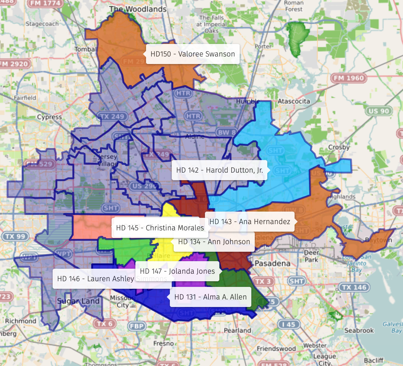
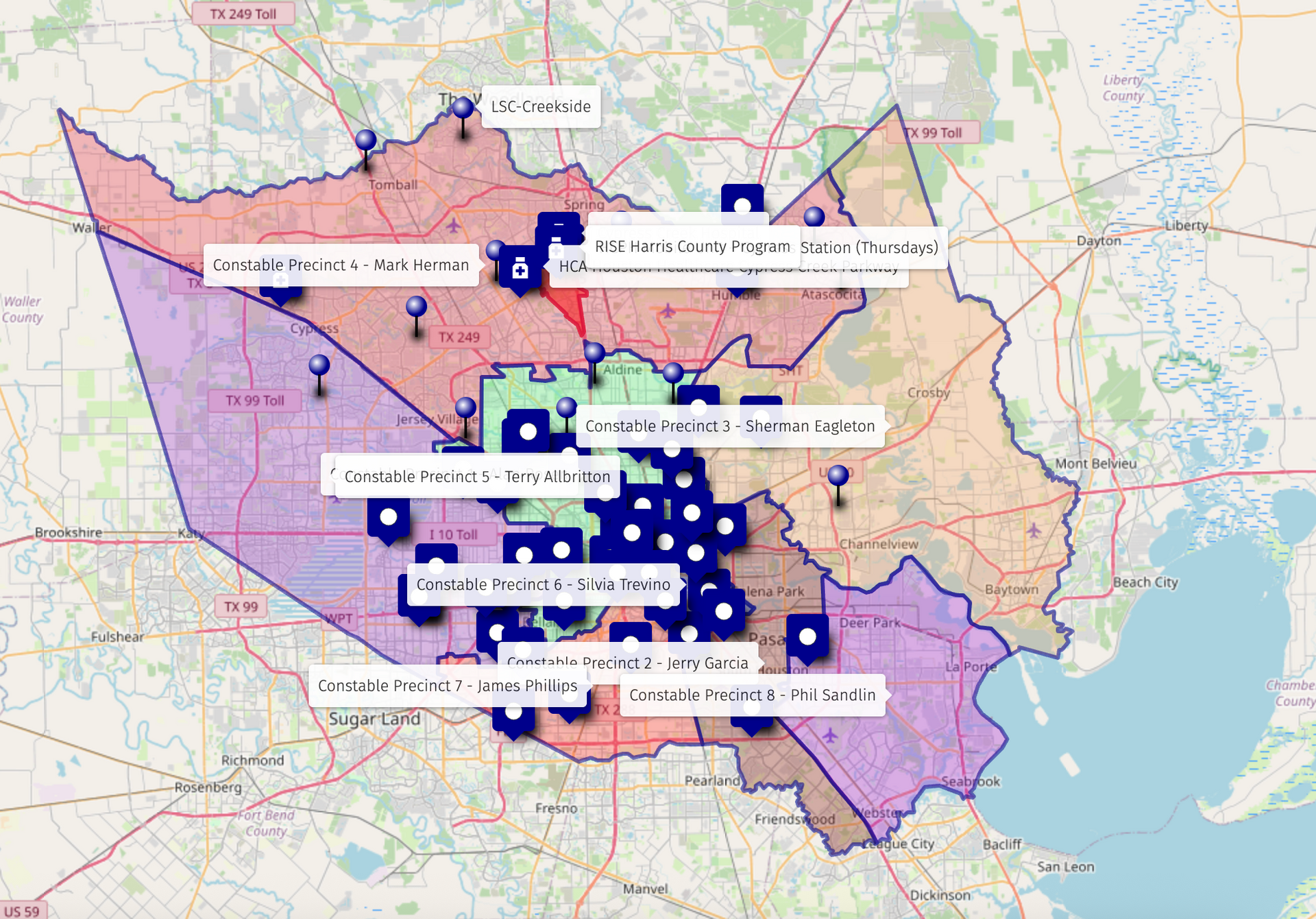
We identify and map relevant governmental entities -- local, county, state, and federal -- that offer resources, funding, services, or advocacy opportunities.
This includes elected officials, public departments, and agencies that align with your mission, helping your organization uncover overlooked supports and build relationships.
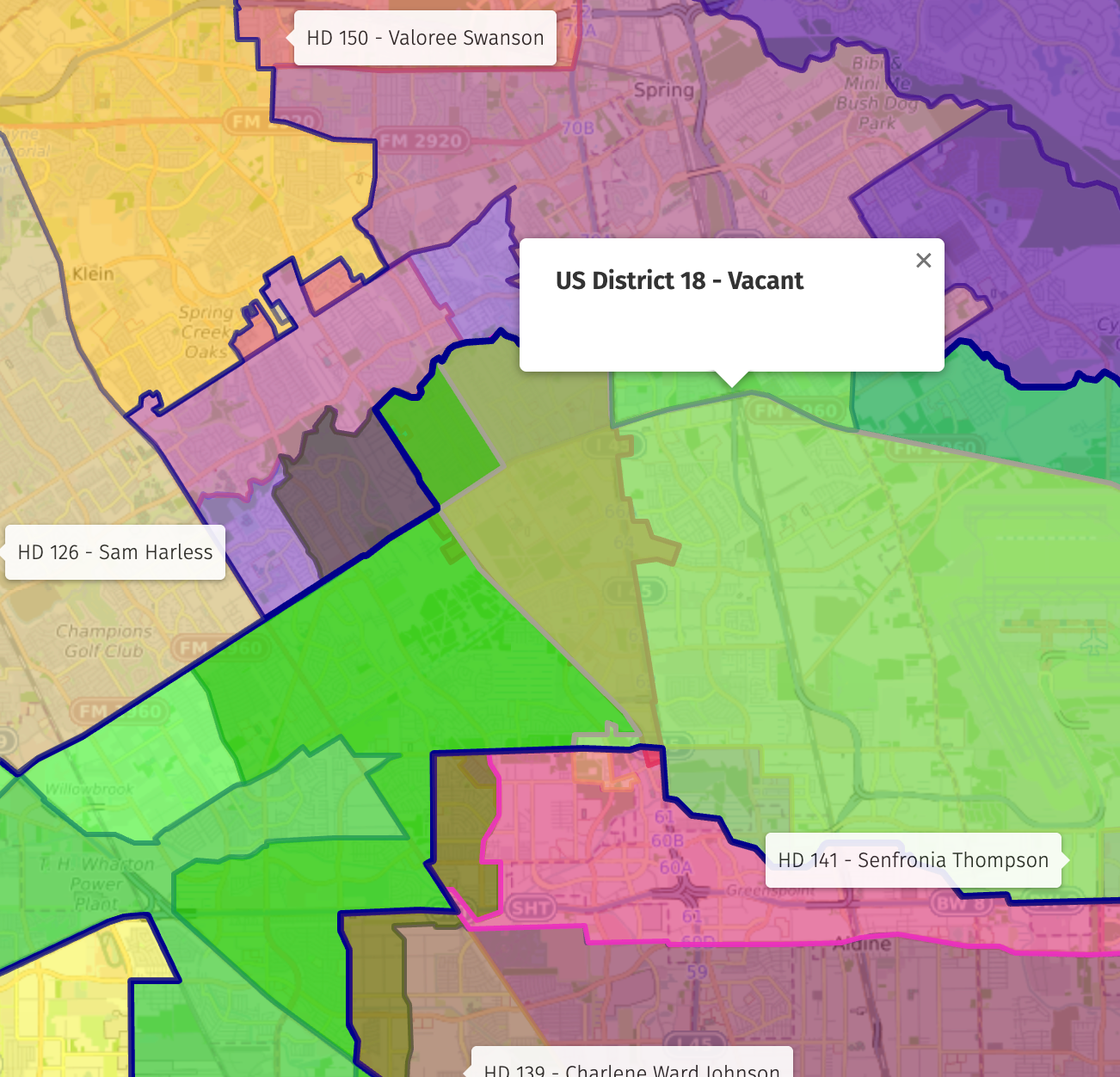
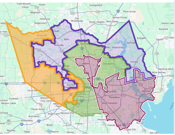
In many communities, the civic landscape is highly fragmented, with neighborhoods split across multiple city council districts, county precincts, school districts, state legislative districts, or even overlapping federal boundaries.
This fragmentation often leads to gaps in visibility, inconsistent support, and the sense that no single office feels fully responsible for the area.
By revealing these divides, we help organizations understand why proactive communication with each civic district is essential.
Layer 1
Civic Systems
This layer identifies the power structures and public assets that determine access, voice, funding, and opportunity.
We identify and map relevant governmental entities -- local, county, state, and federal -- that offer resources, funding, services, or advocacy opportunities.
This includes elected officials, public departments, and agencies that align with your mission, helping your organization uncover overlooked supports and build relationships.
In many communities we analyze, the civic landscape is highly fragmented — with neighborhoods split across multiple city council districts, county precincts, school districts, state legislative districts, or even overlapping federal boundaries.
This fragmentation often leads to gaps in visibility, inconsistent support, and the sense that no single office feels fully responsible for the area.
By revealing these divides, we help organizations understand why proactive communication with each civic district is essential.
Layer 2
Collaborative Networks
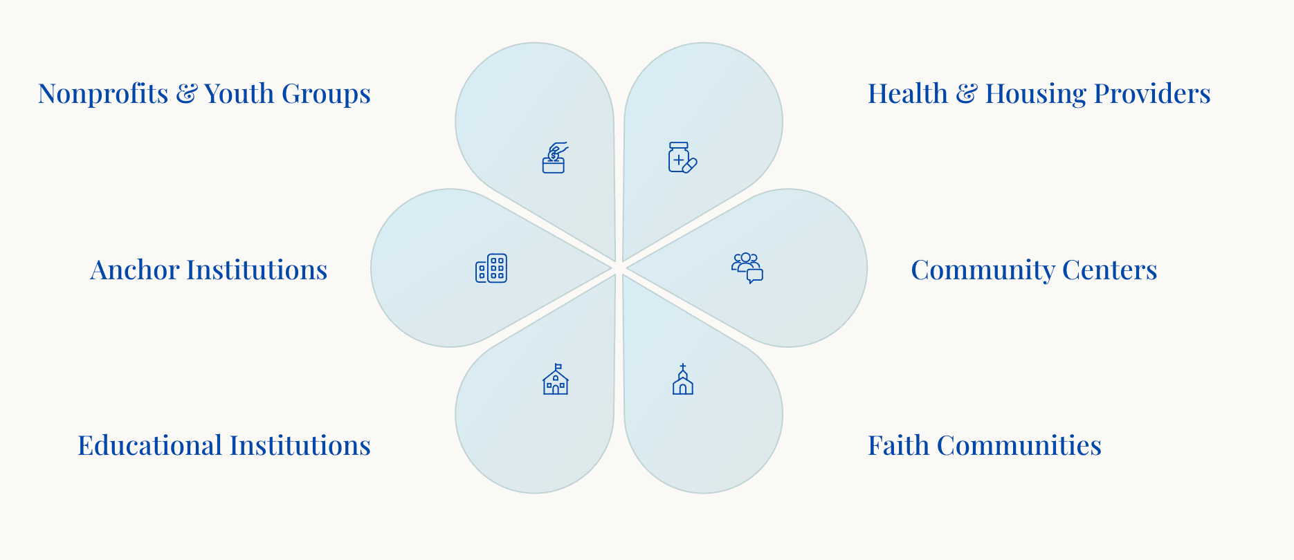
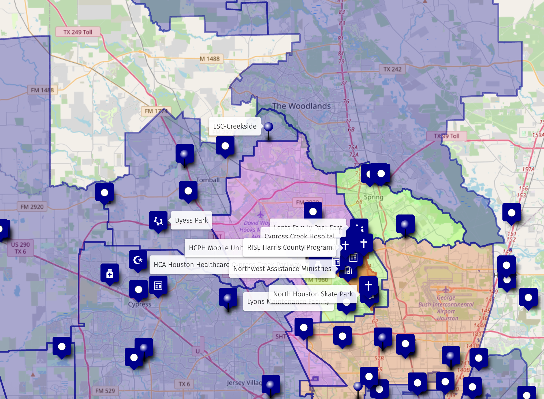
This layer identifies all the potential partners around you, organizations doing work that complements, strengthens, or expands yours. This surfaces where collaboration is possible and where shared missions can become shared strategies.
We map and highlight organizations, institutions, and networks in your area that could become high-impact partners. These groups might include nonprofits, public schools , public health providers, coalitions, or civic groups whose work complements your own.
In many community-analysis projects, this collaborative mapping reveals a wide spectrum of practical and high-value partnership opportunities.
Layer 3
Competitive Awareness
This layer identifies the organizational "neighbors" in your work -- those offering similar services, targeting similar populations, or operating in the same space.
What This Layer Reveals
- Who is doing similar work
- Where duplication exists
- Where gaps in service remain
- How your organization can differentiate and sharpen its message
This layer isn’t about creating a zero-sum 'advantage' -- it’s about mapping your place in the community to give you the awareness needed to clarify your distinct value.
With this insight, you can refine your messaging, avoid overlap or confusion, and present a sharper, more compelling case to funders, partners, and community stakeholders.
Layer 2
Collaborative Networks
This layer identifies all the potential partners around you -- organizations doing work that complements, strengthens, or expands yours. This surfaces where collaboration is possible and where shared missions can become shared strategies.
We map and highlight organizations, institutions, and networks in your area that could become high-impact partners. These groups might include nonprofits, public schools , public health providers, coalitions, or civic groups whose work complements your own.
In many community-analysis projects, this collaborative mapping reveals a wide spectrum of practical and high-value partnership opportunities.
Layer 3
Competitive Awareness
This layer identifies the organizational "neighbors" in the work -- those offering similar services, targeting similar populations, or operating in the same space.
What This Layer Reveals
- Who is doing similar work
- Where duplication exists
- Where gaps in service remain
- How your organization can differentiate and sharpen its message
This layer isn’t about creating a zero-sum 'advantage' -- it’s about mapping your place in the community to give you the awareness needed to clarify your distinct value.
With this insight, you can refine your messaging, avoid overlap or confusion, and present a sharper, more compelling case to funders, partners, and community stakeholders.
Why the 3 Layers Matter
When organizations see these three layers together, everything becomes clearer. The combination transforms how you understand your position, identify opportunities, and move forward strategically.
Civic Engagement
Know exactly which civic offices to engage and how their priorities align with your mission
Strategic Partnerships
Identify which partners to build alignment with for maximum collaborative impact
Differentiation
Understand how to stand out in a complex ecosystem while avoiding duplication
Strategic Opportunities
See where the true leverage points lie within your community landscape
The Bird's Eye Atlas
Our Signature Deliverable
Our signature deliverable is a comprehensive, insight-rich document that gives organizations a clear, strategic view of the community ecosystem they operate in. Most organizations only see a small portion of their environment. The Atlas shows the entire landscape.
It takes our 3-Layer Context Map and transforms it into a structured guide leaders can use to make informed decisions, build partnerships, and communicate their story with clarity.
Listen to 'What is the Atlas'
Complete Civic Mapping
All districts, precincts, and civic supports—showing who governs your geography and where power, funding, and influence exist
Collaborative Partner Identification
Strategic partners mapped across your area, highlighting where alignment exists and new collaboration can unlock impact
Competitive Landscape Analysis
Organizations doing similar work, service overlaps, and gaps—helping you sharpen your message and differentiate effectively
Baseline Analysis Narrative
A readable overview explaining your community context, decision-makers, opportunities, and how your mission fits the landscape
Presentation Materials
Ready-to-use slide decks, PDF summaries, and optional video or audio briefings for boards, funders, and community presentations
Custom Interactive Map
Online map you can zoom, filter, share, and embed; providing visual representation of all three layers
1 - Civic Supports
We identify and map relevant governmental entities—local, county, state, and federal—that offer resources, funding, services, or advocacy opportunities. This includes elected officials, public departments, and agencies that align with your mission, helping your organization uncover overlooked supports and build relationships.
In many communities we analyze, the civic landscape is highly fragmented — with neighborhoods split across multiple city council districts, county precincts, school districts, state legislative districts, or even overlapping federal boundaries.
This fragmentation often leads to gaps in visibility, inconsistent support, and the sense that no single office feels fully responsible for the area. Our mapping brings this complexity to the surface, showing where responsibility is diffuse and where important districts may be unaware of the community’s needs.
By revealing these divides, we help organizations understand why proactive communication with each civic district is essential: when a community sits at the edge of multiple boundaries, it is often unintentionally overlooked. Our approach equips you to build consistent relationships across all relevant offices so your mission remains visible, supported, and understood.
2 - Collaborative Opportunities
We map and highlight organizations, institutions, and networks in your area that could become high-impact partners. These groups might include nonprofits, public schools , public health providers, coalitions, or civic groups whose work complements your own.
In many community-analysis projects, this collaborative mapping reveals a wide spectrum of practical and high-value partnership opportunities.
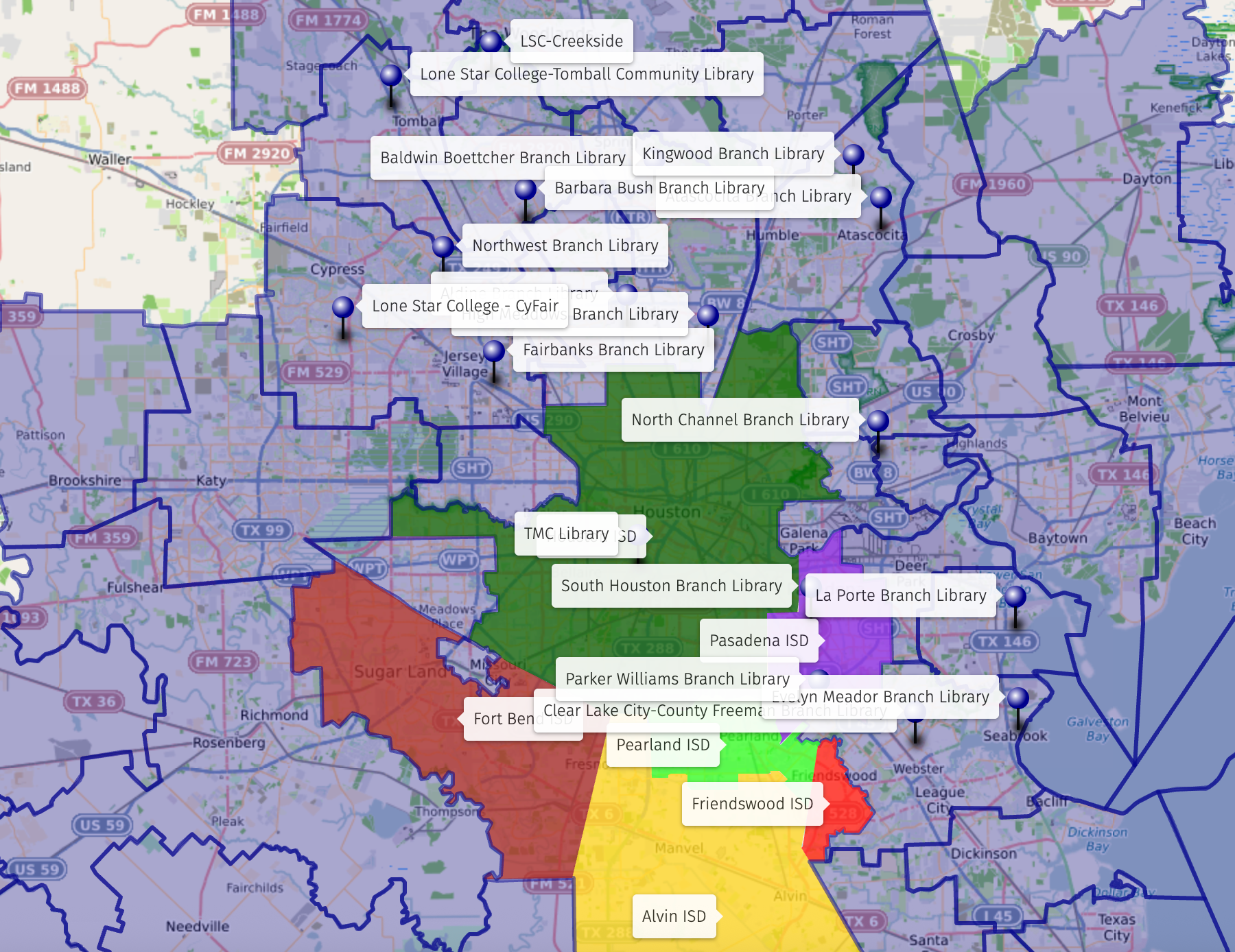
For example, literacy-focused initiatives often emerge across multiple sectors — from public library systems (including mobile library units) and community literacy nonprofits, to school-based programs and family resource centers. We frequently identify adjacent partners whose missions support overall community well-being, such as local assistance ministries, youth development organizations, public health providers, and homelessness response agencies.
By visualizing these networks together, we help clients see where natural alliances already exist, where complementary programs can reinforce their mission, and where targeted introductions could unlock shared resources or coordinated service delivery.
3 - Competitive Awareness
Understanding your competitive environment is essential for clear and effective positioning. We identify organizations and programs that serve similar constituents or operate in the same issue space, mapping their locations, understanding how they present themselves, identifying services they offer, and observing where they are most visible.
This layer isn’t about creating a zero-sum 'advantage' — it’s about giving you the awareness needed to clarify your distinct value. With this insight, you can refine your messaging, avoid overlap or confusion, and present a sharper, more compelling case to funders, partners, and community stakeholders.
From Insight to Impact: The Bird's Eye Atlas
Once we map your organization within the broader civic, collaborative, and competitive landscape, we help you turn that perspective into action with the Bird's Eye Atlas.

The Bird’s Eye Atlas is a complete suite of insights and tools -- combining data, maps, and narrative to give organizations a clear, actionable view of their community.
The Atlas includes a Baseline Analysis, Civic & Collaborative Map, Executive Summary & Program Recommendations, The Advocacy Book, and a Stakeholder Presentation — together forming a comprehensive reference for strategy, collaboration, and advocacy.
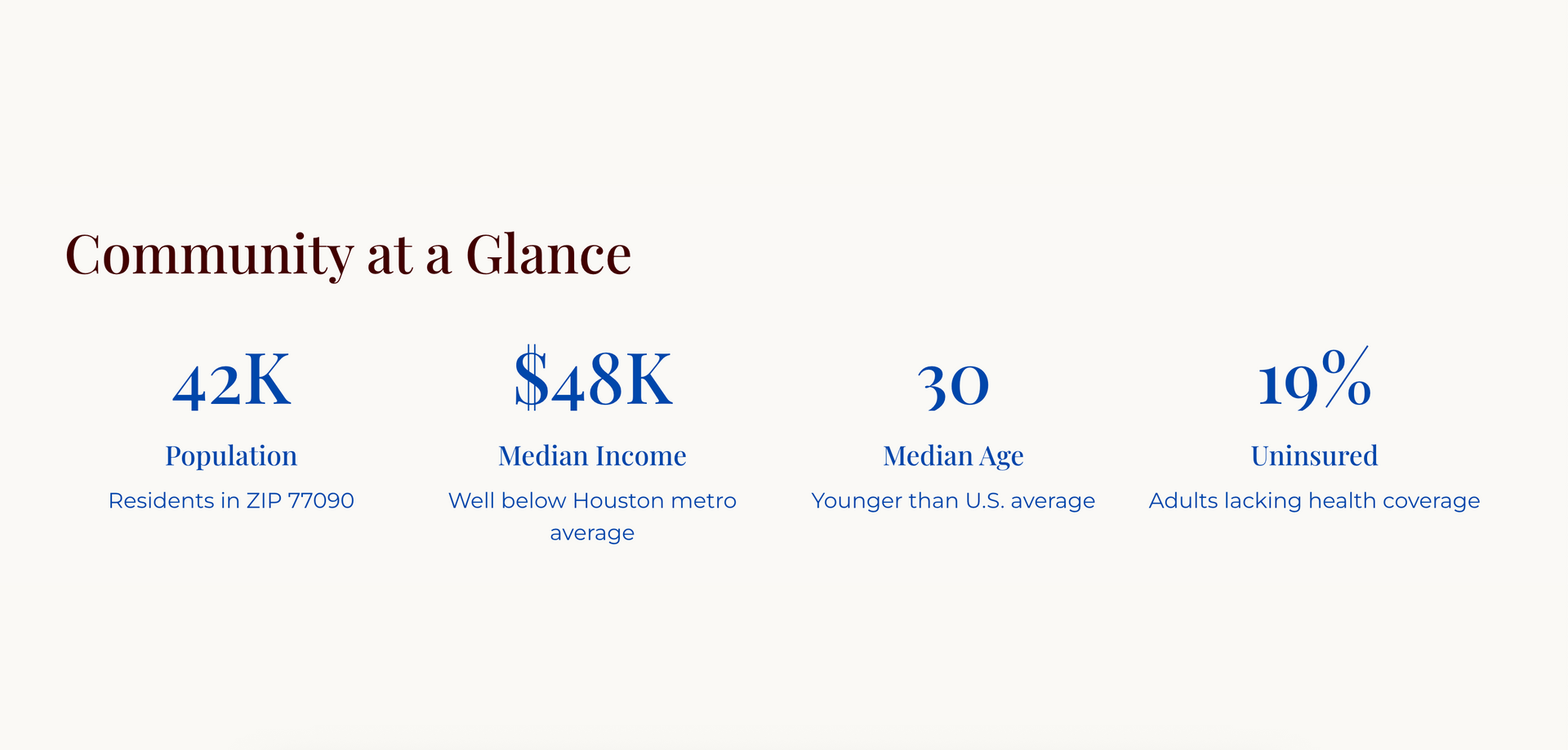
Resource 1: Baseline Community Analysis and Socio-Economic Context
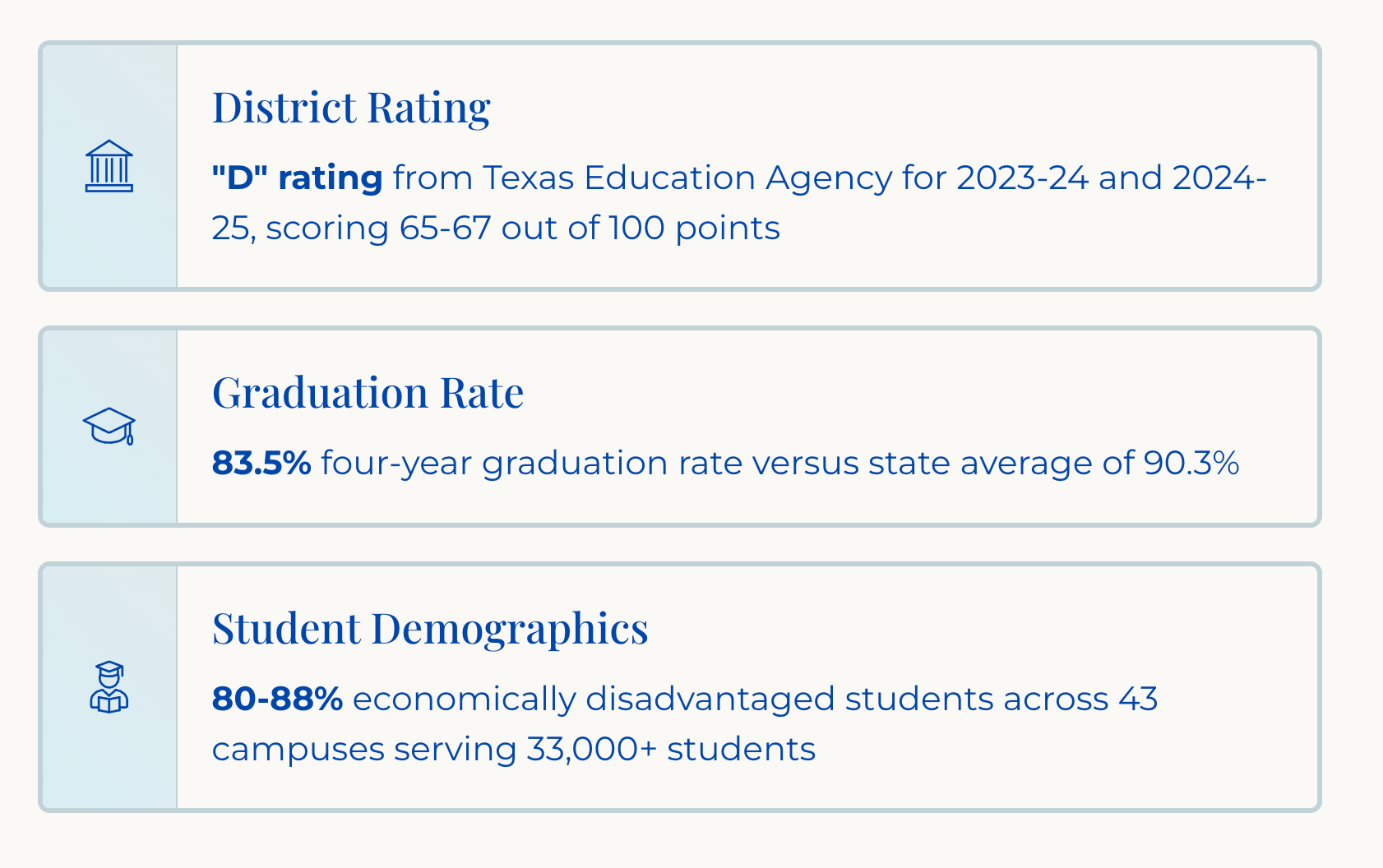
We provide a detailed demographic overview and data-driven analysis of your operating landscape. This includes crucial socio-economic indicators such as population size, median household income, median age, educational attainment rates, housing composition (e.g., high rental density), and challenges like the percentage of uninsured residents.
Our analysis identifies core challenges in the community, such as educational attainment gaps, housing vulnerability, crime rates, and limited mobility, which constrain resources and opportunity.
Resource 2: Civic and Collaborative Map
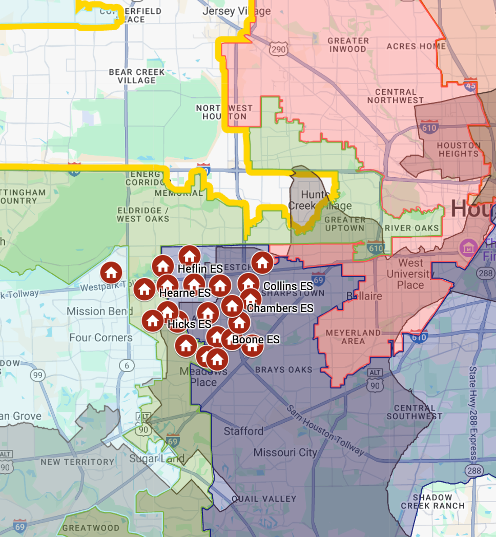
This deliverable visually maps the geography of opportunity and challenge. The map includes the area's Civic Supports (local, county, state, and federal jurisdictions) and identifies Collaborative Opportunities (partnerships with schools, libraries, parks, community centers, health providers, and faith-based organizations).
This mapping addresses the jurisdictional challenges often faced by communities, such as fragmented services and coordination gaps.
Resource 3: The Advocacy Reference Book
This resource serves as a centralized guide to relevant civic and collaborative resources. It includes key contacts and outlines resources necessary for advocacy, leveraging the information gathered through our Civic Supports and Collaborative Opportunities mapping.
This book is a tool to help transform civic fragmentation into collaborative momentum.

Resource 4: Executive Summary and Program Recommendations
We provide an Executive Summary of the analysis outlining the strategic findings and our recommendations for action. Recommendations are focused on coordinated local initiatives designed for long-term outcomes.
This mapping addresses the jurisdictional challenges often faced by communities, such as fragmented services and coordination gaps.
Resource 5: Refined Stakeholder Presentation
A polished, presentation-ready version of the analysis, recommendations, and strategic plan, suitable for delivery to stakeholders, board members, funders, and community members.
This presentation helps your organization advocate for community needs and demonstrates measurable progress. It communicates how strategic investment delivers exponential returns compared to crisis intervention.
Our Signature Approach:
The
3-Layer
Map Context
Bird's Eye Impact delivers tailored geographic and organizational analysis using a three-part mapping method:
1. Civic Supports
We identify and map relevant governmental entities—local, county, state, and federal—that offer resources, funding, services, or advocacy opportunities.
This includes elected officials, public departments, and agencies that align with your mission. By visualizing these connections, we help your organization uncover overlooked supports and build relationships that can unlock new opportunities for growth, influence, and sustainability.
2. Collaborative Supports
We map and highlight organizations, institutions, and networks in your area that could become high-impact partners. These might include nonprofits, schools, health providers, coalitions, or civic groups whose work complements your own.
By identifying where missions align or audiences overlap, we help you strategically engage collaborators who can expand your reach, share resources, and strengthen program delivery.
3. Competitive Sets
Understanding your competitive landscape is key to strategic positioning. Bird’s Eye Impact maps organizations with similar missions or services in your area, helping you assess their visibility, funding sources, and programming focus. This insight allows you to clearly define what makes your work distinctive—so you can differentiate your brand, make a stronger case to funders, and sharpen your messaging.
Ready to Get Started?
The Bird's Eye Impact team brings decades of experience in nonprofit leadership, public affairs, and mission-driven business operations.
We use this expertise to help you see the full picture and navigate toward impact.
Are you ready to unlock the opportunity in your community?
Get in touch to discuss how our 3 Layer Map Context analysis and the Bird's Eye Atlas can identify opportunities to support your mission.